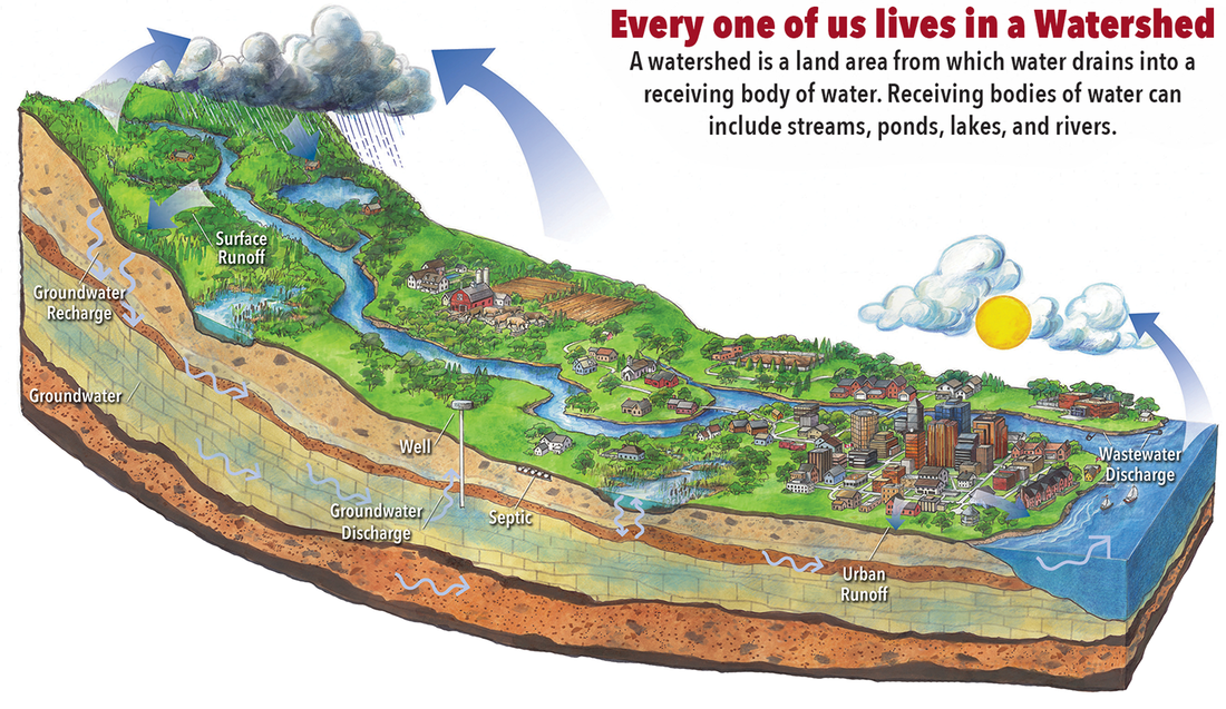
A watershed is the area of the land's surface that drains to a particular water body. Boundaries are generally based on high elevations.
For instance, the continental divide is North America's most famous watershed boundary. On the east side of the continental divide, the rivers and other water bodies all drain to the Atlantic Ocean. On the west side of the continental divide, all of the waters drain to the Pacific Ocean.
Watersheds may be characterized by their size. Large watersheds may encompass thousands of square miles; small watersheds may include only several square miles. The Lake Michigan Watershed, a large watershed, includes 45,598 square miles. This gives a watershed-to-water surface area ratio of about 2:1, which is relatively low. Lake Michigan’s water originates from precipitation falling throughout its watershed.
Watershed Features
The features of a watershed influence the characteristics of its receiving water body. These features include things like:
- Soils
- Vegetation
- Climate
- Topography
- Geology
- Human Land Use
Water Quality and Pollution
The water quality of a lake is a reflection of the activities surrounding it within its watershed. There are two major types of pollution: point source and nonpoint source.
Point source pollution comes from an easily identifiable source, such as a discharge pipe from a factory.
Learn more about a specific watershed
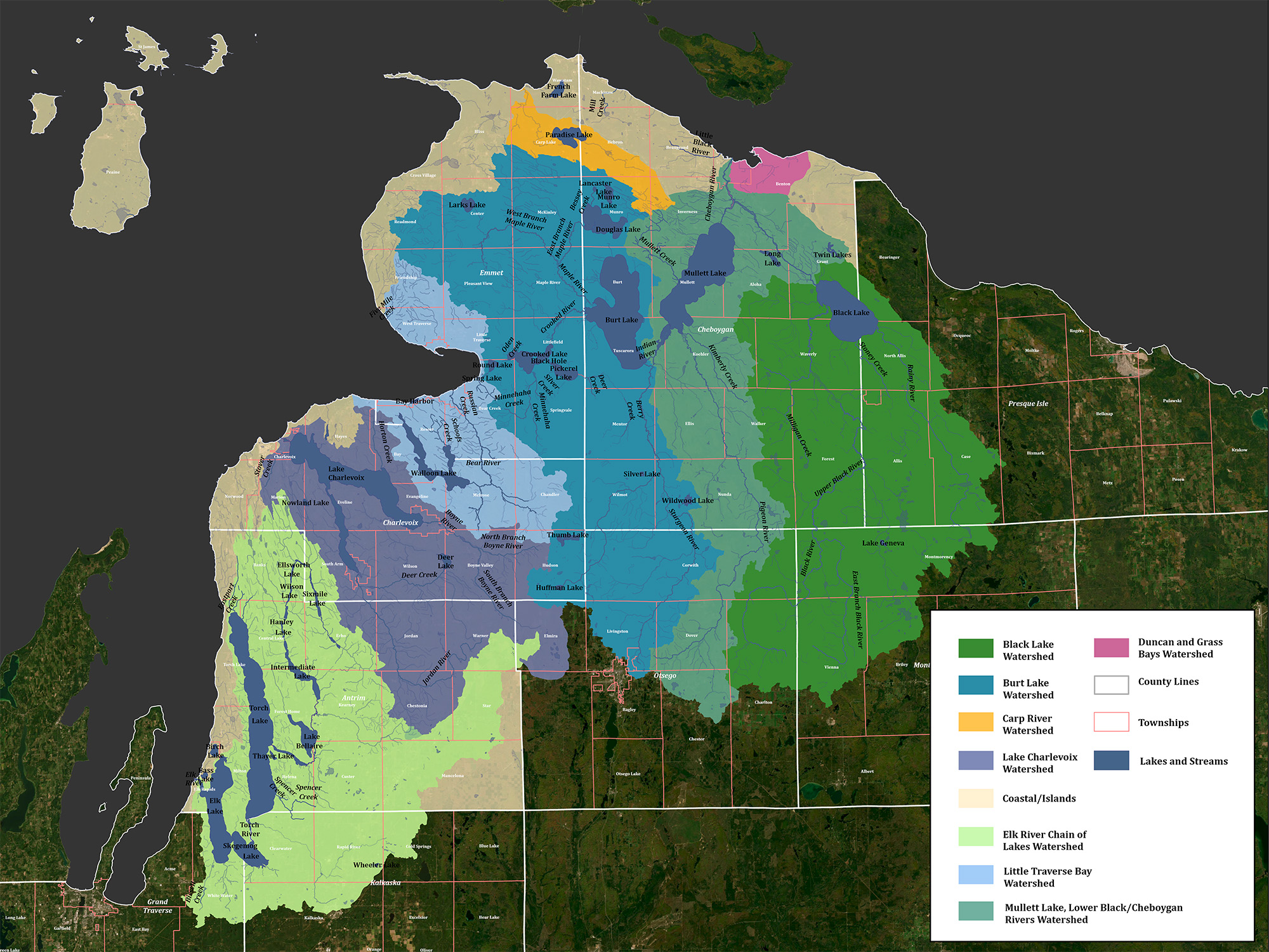
Black Lake Watershed
Description: The Black Lake Watershed is well known for its recreational opportunities and aesthetic appeal. Boating, swimming, and
Burt Lake Watershed
Description: The Burt Lake is one of Michigan’s premier inland lakes. The beauty of Burt Lake has attracted visitors for more
Cheboygan River Watershed
Description: The Cheboygan River Watershed – long recognized by local residents and conservation groups for its natural resource
Duncan-Grass Bay Watershed
Duncan and Grass Bays Watershed Protection Plan: The Duncan and Grass Bays Watershed Protection Plan (Plan) is the result of
Elk River Chain of Lakes Watershed
The Elk River Watershed, covering over 500 square miles, is the largest sub-watershed of Grand Traverse Bay. It
Lake Charlevoix Watershed
Description: Lake Charlevoix is one of Michigan’s premier inland lakes. With a surface area of over 17,200 acres
Larks Lake Watershed
Description: Larks Lake is a small, shallow lake located in Center Township in northern Emmet County. Larks Lake
Little Traverse Bay Watershed
Description: For centuries, the Odawa Indians made their home along the lakeshore of Little Traverse Bay. The strategic
Mullett Lake Watershed
Description: A watershed is a natural unit which is utilized to develop an ecosystem approach to lake management
Pickerel-Crooked Lakes Watershed
Description: Lake Overview Lake managers and water quality experts have developed standard size and shape measurements to describe
Walloon Lake Watershed
Description: Walloon Lake is located within the Little Traverse Bay Watershed and empties into Lake Michigan through the
Watershed Management Plans
| Title | Link |
|---|---|
| 2024 Mullett Lake, Lower Black/Cheboygan Rivers Watershed Management Plan | |
| 2022 Larks Lake Watershed Management Plan | |
| 2022 Elk River Chain of Lakes Watershed Management Plan | |
| 2021 Coastal Grand Traverse Bay Watershed Plan | |
| 2018 Burt Lake Watershed Management Plan | |
| 2012 Lake Charlevoix Watershed Management Plan |
Watersheds in Our Service Area
Click image to enlarge
EGLE/EPA approved watershed management plans:
Burt Lake Watershed Management Plan
Duncan-Grass Bays Watershed Management Plan
Elk River Chain of Lakes Watershed Management Plan (in-progress)
Lake Charlevoix Watershed Management Plan
Little Traverse Bay Watershed Protection Plan
Mullett Lake Watershed Management Plan (in-progress)
Other Plans:
Black Lake Watershed Stewardship Initiative
Cheboygan River Watershed Habitat Partnership Conservations Area Plan
Grand Traverse Bay Watershed Management Protection Plan
Larks Lake Watershed Plan
Lower Black River Watershed Management Initiative
Mullett Creek Watershed Management Plan
Paradise Lake Management Plan
Pickerel-Crooked Lakes Nonpoint Source Pollution Management Plan
Stover Creek Restoration and Management Plan
Tannery Creek Watershed Management Plan
